Big Data Digest Production
The weather in spring can change faster than you can turn a page; one moment it’s sunny, the next moment there’s a raging storm.
In fact, accurately predicting the weather weeks or even minutes in advance is a scientific challenge that has a broad impact on society.
Currently, many meteorological agencies use prediction models based on atmospheric physics. Although these models have seen significant improvements over the past few decades, they remain constrained by their inherent computational demands and are highly sensitive to estimates of the physical laws that govern them.
Another method for weather prediction is the use of deep neural networks, which not only overcome these limitations but also discover data patterns without encoding explicit physical laws. With the powerful parallel computing capabilities of dedicated hardware like GPUs and TPUs, these networks learn complex transformations from inputs to reasonable outputs.
Building on previous research on precipitation prediction, we introduce “MetNet”: a neural network weather model for precipitation prediction. This deep neural network model can predict precipitation within the next 8 hours at a resolution of 1 kilometer and at 2-minute intervals.
Previous research reference:
https://ai.googleblog.com/2020/01/using-machine-learning-to-nowcast.html
MetNet’s prediction time is 7-8 hours ahead of the most advanced physics-based model currently used by the National Oceanic and Atmospheric Administration (NOAA), and it can predict the entire United States in seconds (instead of hours). The input to the neural network model comes from radar stations and satellite networks, requiring no manual labeling; the model output is a probability distribution, which we can use to infer the most likely precipitation rates under relevant probabilities for each geographic area.
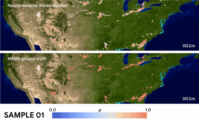
The following image is an example of the neural network model’s prediction for the continental United States:
Comparison of MetNet’s predictions with ground truth measurements from NOAA’s Multi-Radar/Multi-Sensor System (MRMS). The upper image shows the probability distribution of a 1mm/hour precipitation prediction made 3 hours in advance, while the lower image shows MRMS data for regions with at least 1mm/hour precipitation during the same time period.
Neural Network Weather Model
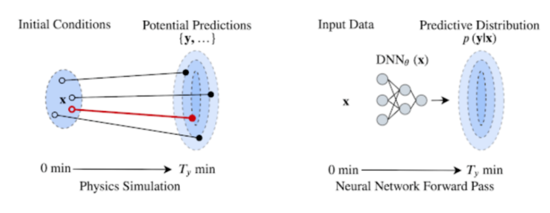
MetNet does not rely on explicit physical laws describing aerodynamics but instead predicts weather directly from observational data through backpropagation learning.
The network uses precipitation estimates derived from ground radar stations that comprise the Multi-Radar/Multi-Sensor System (MRMS), as well as indicators from NOAA’s Geostationary Operational Environmental Satellite System (which provides a top-down view of atmospheric cloud layers). These two data sources cover the continental United States, providing a graphical input that the network can effectively process.
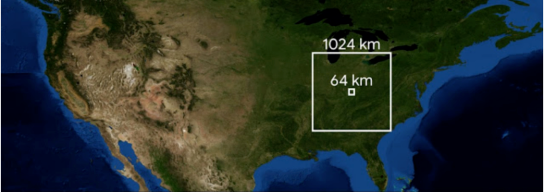
The model predicts for the entire United States at a resolution of 1km, using an area of 64km*64km. However, the actual physical coverage area of the input data corresponding to these output regions is much larger, as it must consider the potential movement of clouds and precipitation fields during the prediction period.
For example, assuming a cloud movement speed of up to 60km/hour, to capture the atmospheric dynamics from 8 hours prior and make informed predictions, the model needs a full spatial context of 60×8=480 kilometers. Thus, to predict the center region of 64km*64km, environmental information must be gathered from a 1024km*1024km area.
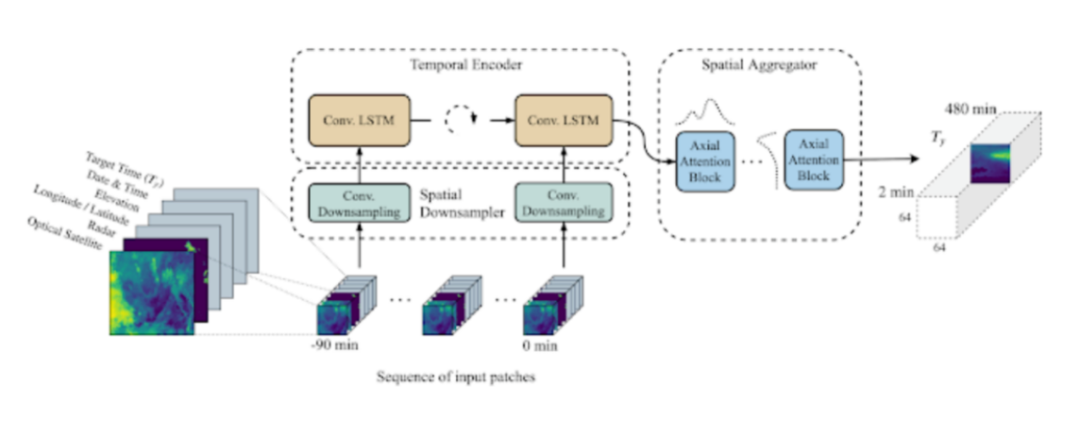
Processing data over a 1024km*1024km range at full resolution requires substantial storage. We use a spatial downsampler to reduce memory consumption by decreasing the spatial dimensions of the input area while discovering and retaining relevant weather patterns in the input.
Next, a temporal encoder is applied along the time dimension of the downsampled input data (implemented with convolutional LSTM, which is particularly suited for image sequences), encoding 7 snapshots of the past 90 minutes of input data at 15-minute intervals. The temporal encoder’s data is sent to a spatial aggregator, which effectively captures long-range spatial correlations in the data using axial self-attention, and outputs predictions for the 64kmX64km area based on a variable amount of environmental context information relative to the target prediction time.
The output of this architecture is a discrete probability distribution for each square kilometer across the continental United States, predicting probabilities at given precipitation rates.
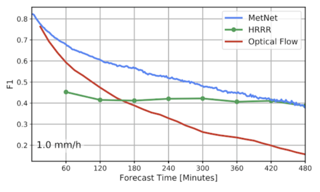
We evaluated MetNet against a precipitation rate prediction benchmark and compared these results with two baselines. These two baselines include NOAA’s High-Resolution Rapid Refresh (HRRR) system, which is the physical weather prediction model currently used in the US, and a baseline model known for its ability to predict precipitation field movement well over the next 2 hours.
A notable advantage of our neural network weather prediction model is its optimization for dense parallel computation, making it well-suited for running on dedicated hardware like TPUs. This allows us to make predictions for specific areas in New York City or across the entire United States in seconds. In contrast, physical models like HRRR require about an hour to run on supercomputers.
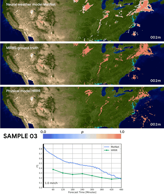
The following image quantifies the differences in results between MetNet, HRRR, and optical flow baseline models. We measure the results of the three models using the F1 score for a 1mm/hour rainfall rate (i.e., light rain). The MetNet neural network weather model outperformed the NOAA HRRR system in predictions made within less than 8 hours and consistently outperformed the optical flow model.
Due to the random nature of the atmosphere, the uncertainty of future weather conditions increases with the length of the prediction time.
Since MetNet is a probabilistic model, we can see the uncertainty of predictions in visualized images, which increases with the prediction time, while the smoothness of predictions also rises. In contrast, HRRR does not directly make probabilistic predictions but predicts a single outcome.
The following image compares the outputs of the MetNet model and the HRRR model:
Compared to the MetNet model, the HRRR physical model’s predictions appear clearer and more structured; however, due to the uncertainty in the model’s initial conditions and parameters, the structural accuracy is lower, particularly regarding the accuracy of the predicted structure’s timing and location.
A more comprehensive comparison of HRRR and MetNet models can be found in the following video:
https://youtu.be/-dAvqroX7ZI
We are actively researching how to improve global weather forecasting, particularly in regions most affected by rapid climate change.
Although we have demonstrated the MetNet model currently for the continental United States, this model can be extended to cover any region with sufficient radar and optical satellite data. The work described in this article is just a small stepping stone in this effort, and we hope to achieve greater improvements through future collaborations with the meteorological community.
https://ai.googleblog.com/2020/03/a-neural-weather-model-for-eight-hour.html
Intern/Full-Time Editor Recruitment
Join us to experience every detail of writing for a professional technology media outlet, growing alongside a group of the best people in the most promising industry. Located at Tsinghua East Gate, Beijing, reply with “Recruitment” on the Big Data Digest homepage dialogue page for details. Please send your resume directly to [email protected]
Reply “Volunteer” to join us

Those who click “Looking” have become more attractive!